The Euphrates River is the longest river in Southwest Asia, watering the lands where the civilisations of Mesopotamia were born. For Gaziantep, however, the Euphrates is not merely a river; it is a ribbon of history that traces the province's eastern shore and links the region's most ancient stops to one another — from Zeugma to Rumkale, from Carchemish to Halfeti on the opposite bank. This page deals with the place of the Euphrates in the geography of Gaziantep — the ancient cities on its banks, the dams upon it and today's nature tourism.
Drawing people to the water's edge for thousands of years, the Euphrates carries the traces of settlement, trade and faith in the Antep region too. In the sections below we begin with the river's general geography and move on to the riverside settlements and modern dams that make it an inseparable part of Gaziantep's history.
The Lifeline of Mesopotamia
With a length of roughly 2,800 kilometres, the Euphrates is the longest river in Southwest Asia; more than half of this length (about 1,260 kilometres) lies within the borders of Türkiye. The river is formed by the joining of the Karasu and Murat branches, which rise in the high mountains of Eastern Anatolia; flowing south, it crosses Southeastern Anatolia, runs through Syria and Iraq, joins the Tigris and reaches the Persian Gulf.
The fertile lands between the Euphrates and the Tigris are known in the history books as the "Fertile Crescent" and as Mesopotamia (that is, "between two rivers"). The Euphrates is the lifeline of this region, where agriculture, writing and the first cities were born. The river's upper basin, which also takes in Gaziantep, is regarded as the gateway in Anatolia to this ancient story.
The Eastern Shore of Gaziantep
The Euphrates flows to the east of Gaziantep, in the section where the province borders Şanlıurfa, and in a sense it traces the city's eastern boundary. Gaziantep's Nizip, Yavuzeli and Carchemish (Karkamış) districts stretch along the western bank of the river; on the opposite shore lie the Birecik and Halfeti districts of Şanlıurfa. The Euphrates is therefore as much a border that separates the two provinces as a bond that brings them together in a shared basin of history and nature.
The Gaziantep shore of the river has been a strategic crossing line since antiquity. The caravan and army routes running east–west crossed the Euphrates at certain fording points; the cities founded around these fords determined the fate of the region. To follow the river's historical weight in the Antep region within a broader frame, you can look at the History of Gaziantep page.
The Ancient Stops on the Banks of the Euphrates
The Euphrates shore of Gaziantep is like an open-air museum of civilisations stacked one upon another. The principal stops on the Antep side of the river and just across from it are these:
- Zeugma: Its name meaning "crossing, bridge" in Greek, Zeugma is the most important ancient crossing city on the Euphrates. Linking the two banks of the river in the Roman period, the city is famous for the floor mosaics of its magnificent villas.
- Rumkale: A castle-settlement rising on a steep mass of rock at the point where the Euphrates meets the Merzimen Stream. Within the borders of the Yavuzeli district, it offers a striking view overlooking the river from above.
- Carchemish: One of the most powerful cities of the Late Hittite period, on the bank of the Euphrates at the Syrian border; it is known for its hieroglyphic Luwian inscriptions.
- Halfeti: The "sunken city" left under the dam waters on the opposite (Şanlıurfa) bank of the Euphrates; it is the starting point for the boat tours and Rumkale visits made from Gaziantep.
As the waters of the Birecik Dam rose, part of Zeugma faced the danger of being submerged. During the rescue excavations carried out as part of an international mobilisation, the city's unique floor mosaics were lifted and taken into protection, and today they are displayed at the Zeugma Mosaic Museum in the city centre. This rescue shows the destructive and the protective face of the Euphrates at one and the same time.
The Dams and the GAP Project
From the second half of the 20th century onward, the Euphrates settled at the centre of Türkiye's largest water and energy projects. The great dams built on the river as part of the Southeastern Anatolia Project (GAP) radically transformed the region's agriculture and energy production. The dams on the Euphrates continue, from upstream to downstream, with the Keban, Karakaya and Atatürk dams; the links nearest to the Gaziantep region are the Birecik and Carchemish dams.
The broad lakes created by these dams rewrote the landscape along the river's banks. The Birecik reservoir turned the fast-flowing Euphrates into a still, mirror-like surface of water in places; these calm waters brought into being both the "sunken city" appearance of Halfeti and the peaceful boat routes around Rumkale. The same waters also left some settlements and ancient remains — above all old Halfeti — under water centuries later.
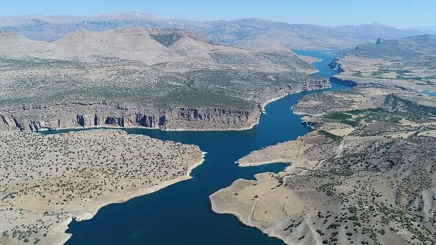
The Euphrates Shore Today
Today the Euphrates shore is one of the most peaceful nature stops around Gaziantep. The boat tours made on the Birecik reservoir take visitors among the sunken village minaret, Rumkale and the steep shore views. The tea gardens, fish restaurants and recreation areas along the riverbank are ideal for those who want to combine a history trip with a break in nature.
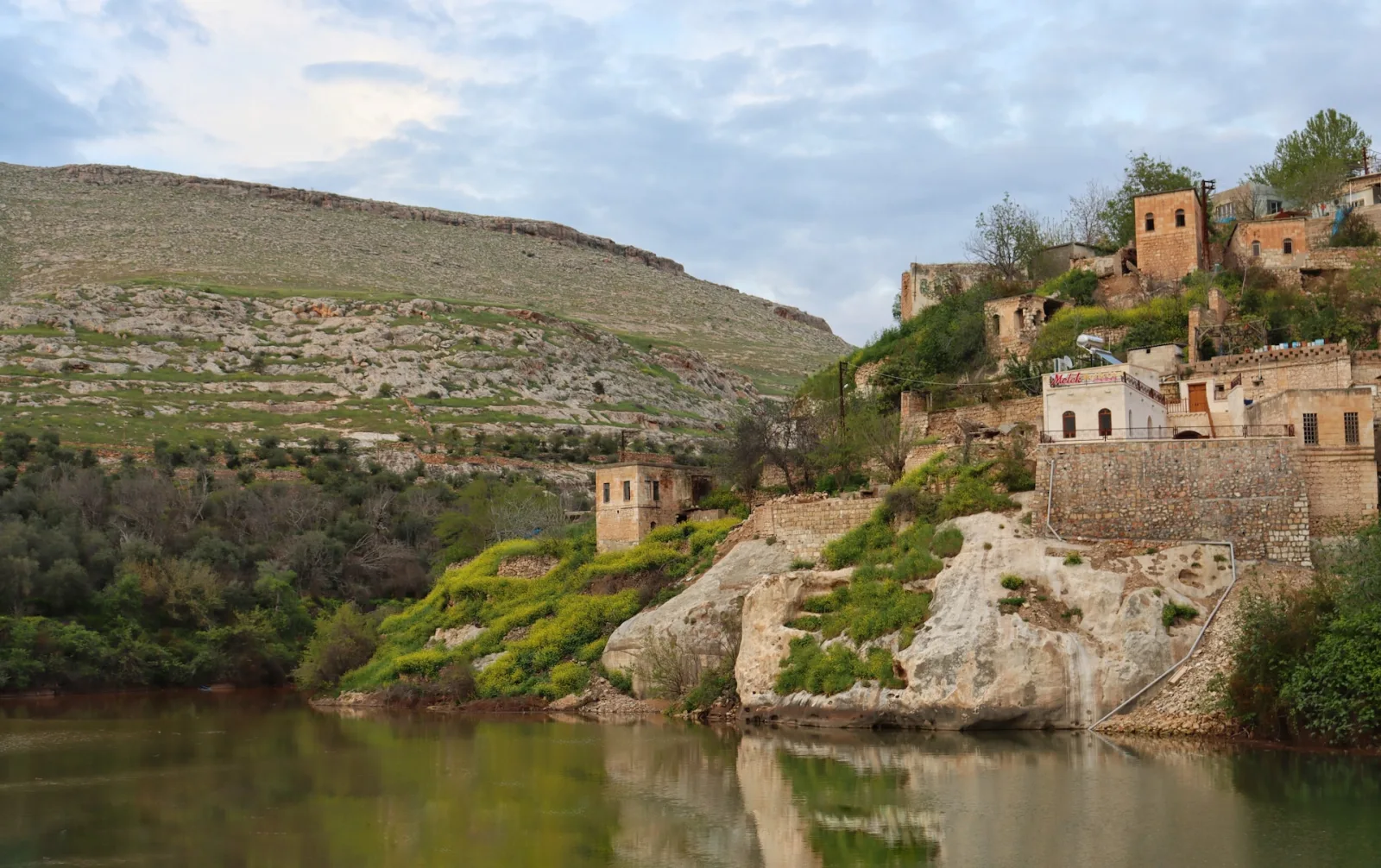
It is possible to think of the Euphrates as the backbone of a trip plan: on the same route, Zeugma and the Zeugma Mosaic Museum, followed by Rumkale and Halfeti, come together to gather the river's thousands of years of history into a single route. To discover Gaziantep's other nature and culture stops, you can browse the Culture Atlas.
Frequently Asked Questions
Where does the Euphrates River rise, and how long is it?
The Euphrates is formed by the joining of the Karasu and Murat branches in Eastern Anatolia and is roughly 2,800 kilometres long. More than half of this length lies within the borders of Türkiye. The river flows south, joins the Tigris in Syria and Iraq, and reaches the Persian Gulf.
What is the relationship between the Euphrates River and Gaziantep?
Flowing to the east of Gaziantep, the Euphrates forms a kind of natural border in the section where the province borders Şanlıurfa. Gaziantep's Nizip, Yavuzeli and Carchemish (Karkamış) districts lie on the western bank of the river; important ancient stops such as Zeugma, Rumkale and Carchemish are on this shore.
Which places can be seen on the Euphrates shore around Gaziantep?
On the Gaziantep side of the river and just across from it lie Zeugma Ancient City, Rumkale, Carchemish and Halfeti on the opposite bank. These stops can also be visited on the boat tours on the Birecik reservoir.
What did the Birecik Dam change on the Euphrates shore?
The lake created by the Birecik Dam turned the flow of the Euphrates into a still water surface in places and brought into being the "sunken city" appearance of Halfeti. In the same process, part of Zeugma faced the danger of being submerged; the city's famous mosaics were lifted in rescue excavations and moved to the Zeugma Mosaic Museum.
Are boat tours run on the Euphrates?
Yes. Boat tours, especially those departing from Halfeti, are run on the Birecik reservoir. These tours offer the chance to see the sunken mosque minaret in Savaşan Village, Rumkale and the other remains along the shore.